The better classes, when they talked about “the poor”, did not mean “the totality of the working class”. For them, “the poor” were those persons who were objectively poor, that is, did not earn enough to eat properly, or were unemployed, or had very bad living conditions. The majority of workers were referred to as “the labouring classes” or “the factory operatives”, and were able to eat enough. In all the manufacturing towns, the really poor lived in clearly defined areas.
M. Faucher in 1844 mentioned “the poor quarters of the town – Angel Meadow, Garden-Street, Newtown, St. George’s Road, Oldham Roads, Ancoats, and Little Ireland. …” (Faucher, 1844, p. 27)
Herr Johann Georg Kohl made visits to several parts of Manchester, including the poor parts near the rivers Irk and Irwell. “Sometimes the work-people of each manufactory form a little community by themselves, living together in a neighbourhood in a little town of their own [probably he means Ancoats]; but in general they occupy particular quarters of the town, which contain nothing but long unbroken rows of small low dirty houses, each exactly like the other. These quarters are the most melancholy and disagreeable parts of the town, squalid, filthy and miserable, to a deplorable degree.” (Kohl, 1844, p.133)
Mr. Nassau Senior, a politician who was a firm proponent of the New Poor Law, visited Manchester on a fact-finding trip. He was steered in the right direction: “The difference in appearance when you come to the Manchester operatives is striking: they are sallow and thinner. But when I went through their habitations in Irish Town, and Ancoats, in Little Ireland, my only wonder was that tolerable health could be maintained by the inmates of such houses.”
(Senior, Nassau W., Letters on the Factory Act, as it affects the Cotton Manufacturer; Addressed to the Right Honourable The President of the Board of Trade; B. Fellowes, London, 1837; p. 16)
“Several of the habitations of the Manchester poor are low, damp, ill-ventilated, and surrounded with filth. This is especially the case in Little Ireland, and the neighbouring district, which is chiefly inhabited by Irish. This, however, the most destitute part of the population, does not in general work in factories; but it would be a great improvement in their condition if they did, as the worst room in a factory is a palace of health and comfort in comparison with their miserable dwellings. The factory workmen are usually in a very comfortable condition, many of their houses displaying neatness, and even elegance in their arrangements; and when I visited them at dinner-time, the occupants were generally eating fresh meat and potatoes.”
(Factories Inquiry Commission, Supplementary Reports, Part I, 1834; D2 Lancashire District, Report by Mr. Tufnell, p. 204)
The rapporteur for Manchester to the Poor Law Commissioners in 1842, Dr. Howard (Physician to the Ardwick and Ancoats Dispensary), made it clear that, although there were really horrible districts in Manchester, these were confined to a small number of regions.
“That the filthy and disgraceful state of many of the streets in those densely populated and neglected parts of the town where the indigent poor chiefly reside, cannot fail to exercise a most baneful effect on their health, is an inference which has fully proved to be well founded; and no fact is better established than that a large proportion of the cases of fever which occur in Manchester originate in these situations.”
(Poor Law Commissioners, Local Reports, 1842, Lancashire, p. 305)
“It appears to me to be unnecessary to lengthen this report by specifying the particular localities in which nuisances, productive of malaria, tending injuriously to affect the health of the inhabitants, and to promote the prevalence of contagious diseases, exist; but it may be well to mention a few of the streets which, either from being unpaved, or without drains, or containing collections of refuse, &c., or being over-crowded and ill ventilated, have been remarked to be particularly unhealthy.”
(ibid., p. 312)
“These two districts [Ancoats and Angel Meadow] are very densely populated, principally by hand-loom weavers and the workpeople employed in the factories, a large proportion of whom are Irish, living for the most part in a state of extreme indigence, and without the least attention to cleanliness. Altogether they comprehend by far the worst quarters of the town both as regards the wet and filthy state of the streets, the dirty, damp and dilapidated condition of the houses, and the improvidence, poverty, and destitution of the inhabitants; and, as might be anticipated, they furnish the great bulk of our fever patients.”
(ibid., pp. 313-314)
“Of the 1042 patients admitted into the House of Recovery [the Fever Hospital] from the 31st May, 1838, to the 31st May, 1839, 276 came from Ancoats district, 320 from Angel Meadow district, 104 from the Collegiate Church district, 141 from Bank Top district, 134 from Deansgate district, and 67 from Salford.”
(ibid., p. 316)
Here we have a map of the Police Districts of the Township of Manchester in 1832, in a report on the activities of the Special Board of Health against the cholera outbreak in 1831-1833.

(Record Society of Lancashire and Cheshire; The Challenge of Cholera: Proceedings of the Manchester Special Board of Health; 1831-1833, ed. Alan J. Kidd and Terry Wyke: Volume CXLV, 2010, p.2.; http://rslc.org.uk/api/file/Vol_145.pdf)
Almost exclusively inhabited by the labouring population: Districts 1, 2, 3, 4, 10
Dwellings of the operatives, and of shopkeepers and tradesmen: Districts 7, 13, 14
Central districts, containing the principal streets, the most respectable shops, the dwellings of the more wealthy inhabitants, and the warehouses of the merchants and manufacturers: Districts 5, 6, 8, 9
Undefined: District 11
Populations of each Police District:
| Newtown | Ancoats | Central | Portland Street |
| No. 2 .. 25581 | No. 1 .. 31573 | No. 5 .. 7275 | No. 3 .. 11431 |
| 3/5 of 4 .. 9337 | 2/5 of 4 .. 6225 | 6 .. 1274 | 7 .. 9784 |
| 9 .. 3318 | ¾ of 8 .. 2058 | ||
| 10 .. 3886 | 12 .. 1859 | ||
| 11 .. 13635 | 13 .. 7269 | ||
| 14 .. 6834 | |||
| ¼ of 8 .. 686 | |||
| 34918 | 37798 | 36908 | 32401 |
(Kay, 1832, p. 30)
The areas identified by Dr. Howard as having the worst sanitation and the highest number of admissions for fever are geographically located as follows:
Ancoats: Square area (400 yds. x 400 yds.) in the eastern corner of District 1, between Oldham Road and Great Ancoats Street; here were the largest cotton mills in Manchester, with workers’ houses around them.
Angel Meadow: In District 2, between Oldham Road and St. George’s Road
Collegiate Church: Central part of District 6.
Bank Top: At the intersection of Piccadilly, Portland Street, and London Road (present Piccadilly Rail Station)
Deansgate: In District 14, between Deansgate, Quay Street, and Liverpool Road.
Little Ireland (commented by Engels): Shown at the southern extremity of District 10 (Little Ireland was cleared and declared unfit for human habitation in 1847)
In 1837 Registration and Marriage Acts for the whole of England and Wales were passed, which provided for the appointment of Registrars for each locality. Mr. William Johns, the Superintendent-Registrar for Manchester, sent a report to the Statistical Society of London with the data collected for 1837-38 and 1838-39. From one of the tables, we see that there was a differentiation between the districts of the Old Township, as to child mortality. Only the areas of Ancoats and St. Georges had horrible figures for mortality under 3 years.
Districts Percentage Proportion of Deaths at different Ages to the Total Mortality in 1837-38
| Under 3 years | From 3 to 5 | From 6 to 15 | From 16 to 25 | From 26 to 50 | From 51 to 70 | |
| Ancoats | 50.16 | 9.62 | 6.08 | 4.52 | 14.97 | 10.52 |
| St. George’s | 48.06 | 9.09 | 4.98 | 6.30 | 16.61 | 10.18 |
| Deansgate | 41.85 | 9.28 | 5.36 | 6.09 | 20.20 | 13.28 |
| London-road | 38.72 | 6.82 | 4.02 | 9.06 | 25.53 | 11.50 |
| Market-street | 25.76 | 6.54 | 6.23 | 9.84 | 28.77 | 16.00 |
(“Ancoats, the chief seat of the cotton mills; St. George’s, containing a large portion of the Irish population”)
(Johns, 1840, p. 194)
The following report by the Manchester Statistical Society, about the condition of the working population, refers specifically to the “district inhabited more than any other in the town by the working classes and by those of the poorest description”. Geographically the area includes the Ancoats district, and also the Police District with the largest number of lodging houses.
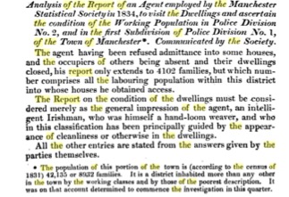

(British Association for the Advancement of Science; Report of the Fourth Meeting, held at Edinburgh in 1834, Report by the Manchester Statistical Association; John Murray, London, 1835; pp. 690-691)
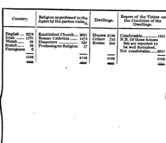
This report shows that the people in these districts had bad housing (60 % not comfortable; 85 % not well furnished), and did not pay much rent. We assume that they did not have good incomes, that is, the average was about 12 shillings for the total family, and a maximum of 16 shillings. However, 30 % paid a monthly charge to a Benefit Club (communal self-insurance for illness or death), and 1 child per family attended Sunday School. Only 0.5 persons per family worked in a factory.
This last point is interesting, because all these people lived near the large cotton mills, which employed perhaps 5,000 workers (men, women and children) in Ancoats. The assumption must be that the lower income workers lived near the factories, and in bad housing conditions, and the skilled workers lived in better areas, at a distance from the factories.
But we do know that these workers, in spite of being poor, had their own “Lyceum” (cultural and educational institute), with a subscription of 8 shillings a year:
(Report of the Proceedings Connected with the Grand Soirée of the Manchester Athenæum, Held on Thursday, October 3rd, 1844: From the Manchester Guardian of Saturday, October 5th, 1844, Printed by Cave & Sever, Manchester, 1844; p. 7)
