Manchester from 1800 to 1837, consisted basically of the Township, which was divided into 14 Police Districts. From 1837, with the introduction of the requirement that births, deaths and marriages should be informed in the Register Offices, the enlarged conurbation was divided into three Registration Districts. These were: Chorlton, Salford, and Manchester. The figure of 350,000 from Engels corresponds to the 341,000 of the 1841 Census for the total of the three Registration Districts.
Different administrative regions of the Manchester area, with populations:
| RD | AreaAcres | 1801 | 1811 | 1821 | 1831 | 1841 | 1851 | |
| Manchester Township | 1,500 | 70,000 | 79,000 | 108,000 | 142,000 | 163,000 | 187,000 | |
| Manchester Parish | 33,500 | 112,000 | 136,000 | 187,000 | 271,000 | 353,000 | 452,000 | |
| 471 | Chorlton | 11,600 | 9,000 | 14,000 | 23,000 | 30,000 | 78,000 | 122,000 |
| 472 | Salford | 4,800 | 19,000 | 25,000 | 34,000 | 52,000 | 70,000 | 88,000 |
| 473 | Manchester | 12,700 | 81,000 | 91,000 | 125,000 | 165,000 | 193,000 | 227,000 |
| Conurbation | 29,100 | 109,000 | 130,000 | 182,000 | 247,000 | 341,000 | 437,000 |
Census of Great Britain 1851, Population Tables I, Vol. II, England and Wales, Divisions VII – IX, Number of the Inhabitants, Division VIII, North-Western Division, p. 8 and pp. 40-42
“RD” = Registration District defined in 1837, with the introduction of the General Register Office.
The centre of the RD Manchester was in 1820 the commercial centre of the town, and also where the business owners lived (*). From 1820 to 1840 the rich moved out to villas in the countryside areas, and the less rich to the suburbs (i. e. Chorlton). These persons converted their town houses to warehouses (a number of which were architecturally impressive). We can see that there was an effect in the population figures: while the Police Districts outside the centre increased in population by 30 % from 1821 to 1831, the four Police Districts of the centre had zero increase in population
The areas included in the RD Chorlton (Ardwick and Chorlton-upon-Medlock) had decent housing and drainage.
Also, a number of the better-paid workers who had been living in the Manchester Township, emigrated to the suburbs. But since the population of the Township in total increased from 1821 to 1831, it must have been the case, that there was an immigration into the Township, greater than the movement from there to the suburbs.
But it is not true that all of the commercial centre was taken up by warehouses and workers’ housing. In 1841-1851 there were a number of entertainment venues, hotels, and business buildings. We shall see this in detail, near the end of this document.
(*) According to Dr. Kay, these were the “central districts, containing the principal streets, the most respectable shops, the dwellings of the more wealthy inhabitants, and the warehouses of the merchants and manufacturers.” 1.01
These were the Police Districts 5 (St. Paul’s), 6 (Exchange), 8 (St. James), 9 (St. Ann’s).
1.01Kay, Dr. J. P., “The Moral and Physical Conditions of the Working Classes employed in the Cotton Manufacture in Manchester”,1832, p. 17.
Map of Manchester, 1845
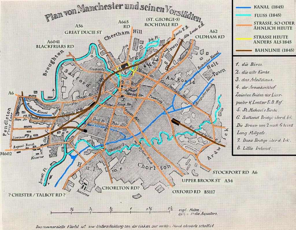
Engels, “Die Lage der arbeitenden Klasse in England”, 1845, End Insert.
Close correspondence with Pigot and Slater, 1841.


Un comentario en “20.6. Divisions of the Manchester Conurbation”